

Ideas Under Awnings
Blaffer Museum, Houston
A collaboration with sound artist Sergei Tcherepnin, painter Henning Bohl, and the University of Houston Dance Department who interpreted short plays as dance that reflected on the collaborative exhibition between Henning Bohl and Sergei Tcherepnin
"Just dispense with traditional notions of mapping"
UH Students Map Unexpected City Sites , Houston Chronicle, By Maggie Galehouse, April 11, 2015
Ordinary maps of Houston are dominated by the Loop, that squarish circle of Interstate 610 that rings downtown.
Forget about the Loop. Forget about the grid of streets clustered inside and out. Forget any preconceptions of a typical map of Houston. In fact, just dispense with traditional notions of mapping altogether.
That was the challenge put to 27 students in a "Creative Mapping" class at the University of Houston. During fall semester, the interdisciplinary arts class devised nine original, individual fold-out maps of Houston, now packaged in a limited-edition atlas called "Unfold: Houston Revealed."
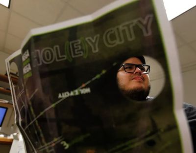
The "Hol(e)y City" map, which boasts circular cutouts, charts potholes around Lakewood Church - the megachurch where Joel Osteen presides.
Quotes from Scripture and Osteen are juxtaposed with pothole facts, road repair data and financial statistics from the city of Houston.
"Maps are not unbiased documents," said Peter Turchi, an English and creative writing professor who co-taught the class with graphic arts professor Cheryl Beckett. "They impose a view of the world."
Link to the article in the Houston Chronicle
A collaboration between poets and graphic designers
University of Houston
Teams of creative writers and graphic designers at the University of Houston created exhibits to help facilitate engagement with the ecosystem of the nearby bay
